
"https://www.lowrance.com/assets/img/default-product-img.png?w=400&h=225&scale=both&mode=max"

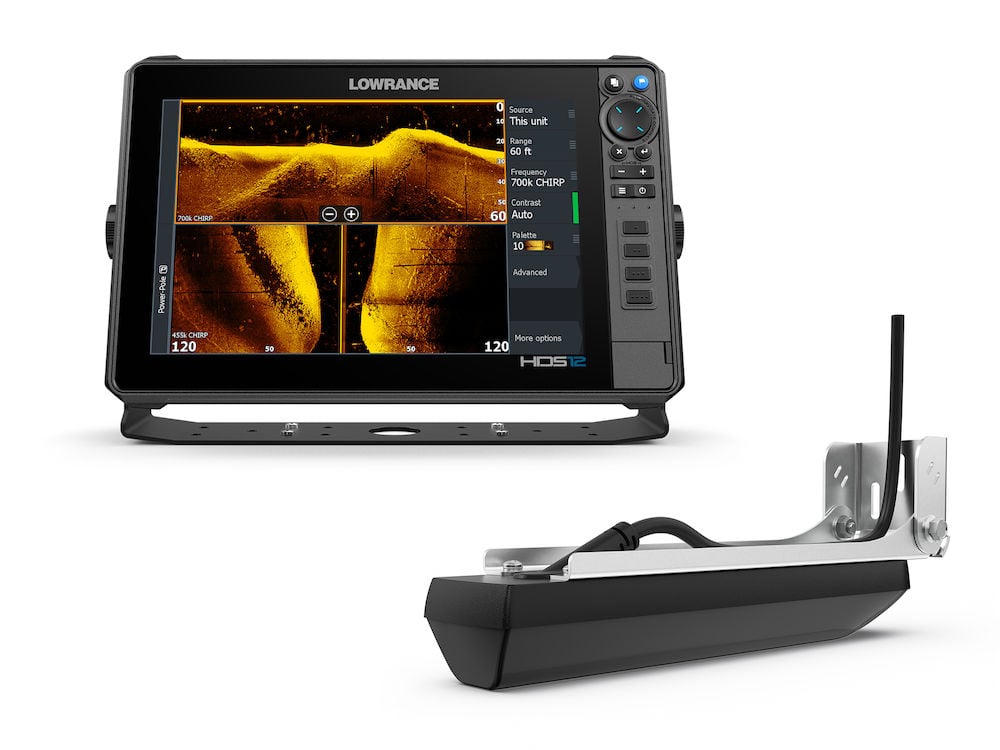
Elite FS 9, No Transducer
SKU: 000-15707-001
000-15707-001The Elite Fishing System (FS) gives you access to the full line-up of Lowrance fishfinding tools – including ActiveTarget® 2 Live Sonar, Active Imaging™ and Active Imaging™ HD and compatibility with a wide range of chart options – to help you make the most of your time on the water.
*Active Imaging HD requires S3100 Module
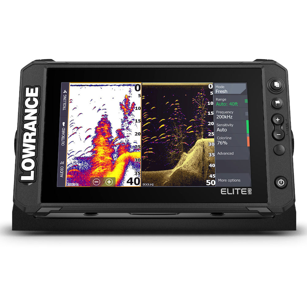
The Elite Fishing System
The Elite Fishing System (FS) combines the power of Lowrance’s proven and newest fishfinding tools with a more affordable display that’s easier to use and install. From integrated support for ActiveTarget™ 2 live sonar and extreme high-resolution Active Imaging™ and Active Imaging HD* with Lowrance CHIRP sonar, SideScan and DownScan Imaging™ with FishReveal™ to preloaded C-MAP® DISCOVER OnBoard fishing maps, Elite FS gives you all the tools you need to find and catch more fish.
*Active Imaging HD requires S3100 Module
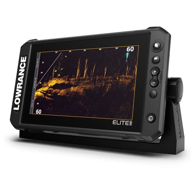
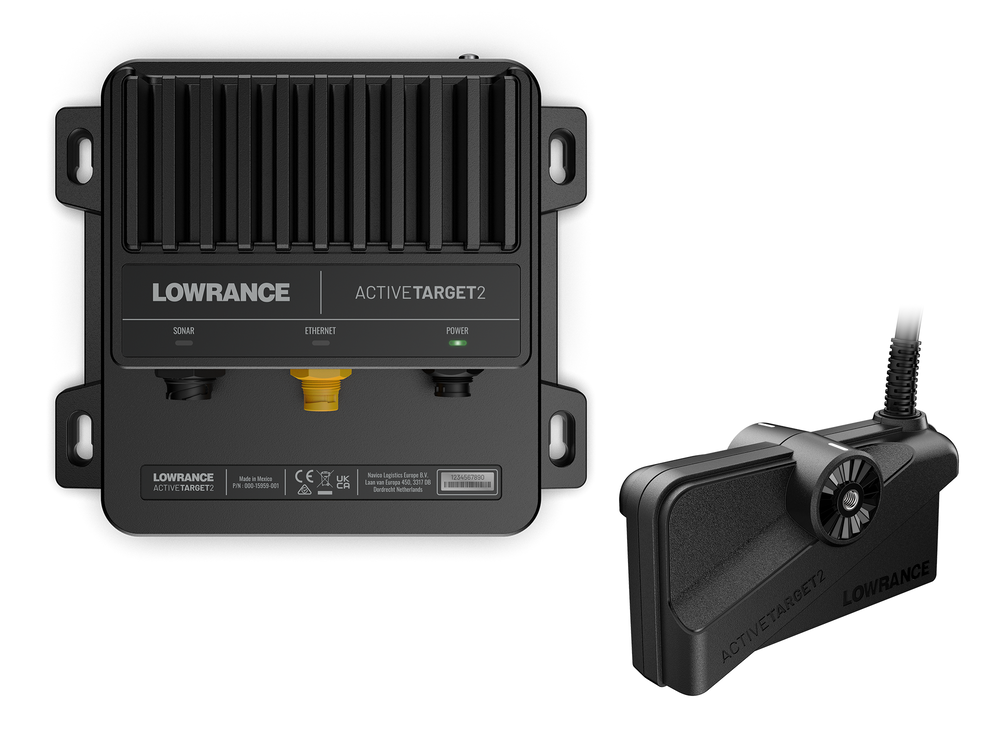
TARGET FISH LIVE WITH ACTIVETARGET 2 LIVE SONAR

Fish smarter when you know exactly what fish are doing – in real time – with ActiveTarget™ 2 Live Sonar. Enjoy high-resolution views of fish movements, tracking them as they swim in and around cover.
Watch their real-time response to your lure and you will know if your current technique is working or if it’s time to switch things up.
Note: No ActiveTarget 2 split screen options in 10 & 12 models
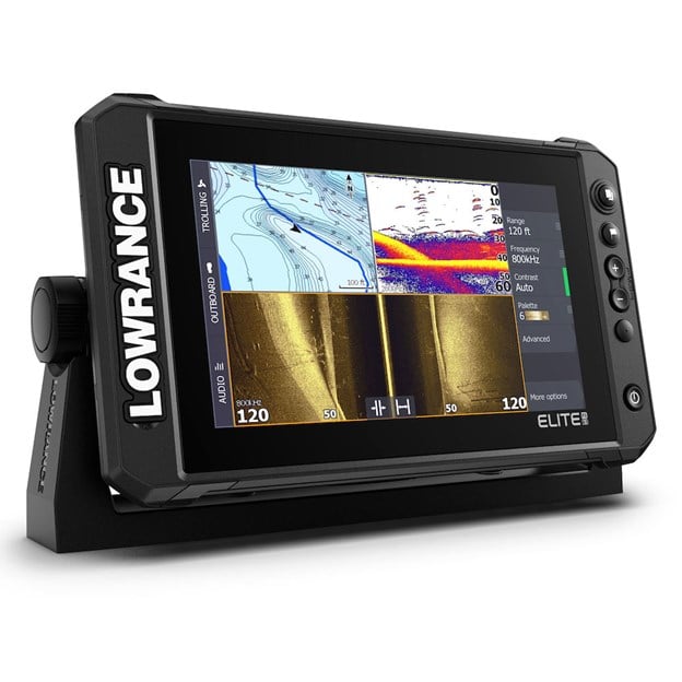
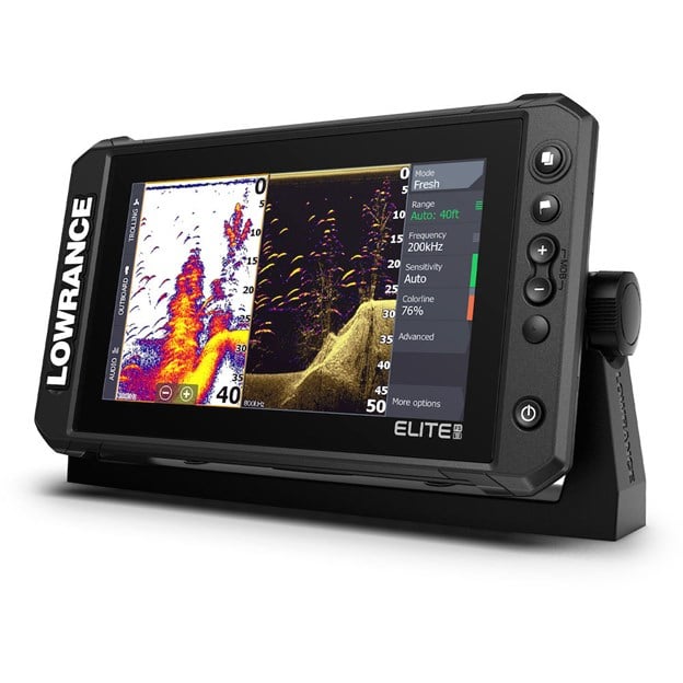
FIND MORE FISH WITH ACTIVE IMAGING 3-IN-1

See structure and cover with a new level of refined detail and at a range unmatched by any other structure imaging technology with Active Imaging™ and Active Imaging™ HD* 3-in-1 sonar featuring CHIRP, SideScan and DownScan Imaging™ with FishReveal™.
Get the best of CHIRP sonar and DownScan Imaging™ on one screen with FishReveal, a Lowrance exclusive that helps you easily recognize fish from structure and cover on high-detailed DownScan images.
*Active Imaging HD requires S3100 Module
FIND KEY FISHING AREAS WITH C-MAP DISCOVER ONBOARD

Spend more time trying to catch fish and less time trying to find them with the high-resolution detail of C-MAP® Discover Onboard inland and coastal charts built into Elite FS displays.
From finding key fishing areas, like ledges, drop-offs and ditches to navigating with precision to fish-holding areas, you will have more success on the water with high-resolution 1-foot contours on 19,000 lakes across the U.S. and more than 9,400 in Canada.
Key Features
- ActiveTarget™ 2 Live Sonar ready
- Active Imaging 3-in-1 ready
- Active Imaging HD 3-in-1 ready with a S3100 Sonar Module
- FishReveal™
- Preloaded C-MAP Discover Onboard with 1-foot contours 19,000 lakes across the U.S. and more than 9,400 in Canada, plus mapping options including C-MAP, Navionics® and more
C-MAP® Easy Routing, Navionics® Autorouting™ capability - C-MAP Genesis Live onscreen mapping
- High-resolution multi-touch touchscreen
- Integrated wireless, NMEA 2000® and Ethernet connectivity
- Full touchscreen control of Recon and Ghost® Trolling Motor, as well as Power Pole® Anchors
- Sirus XM weather compatibility with WM4
Related Items


-
 HDS/Elite/Hook/Mark Power Only Cable
-
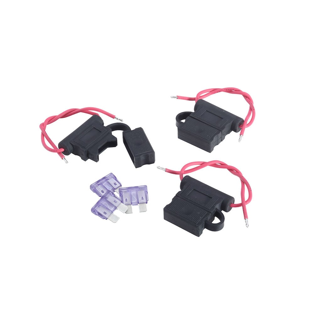
 Fuse and fuse holder
-
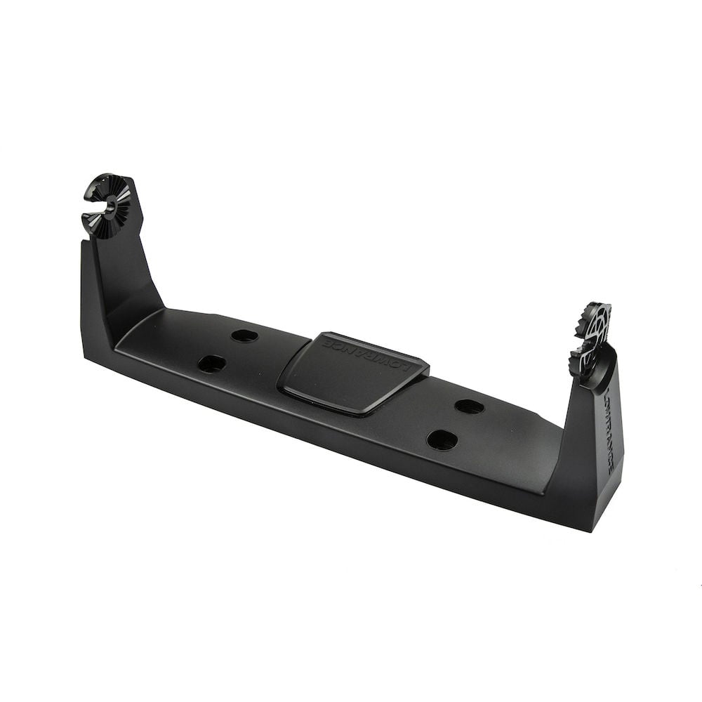
 HDS-9 LIVE/PRO / Elite FS 9 Bracket
-
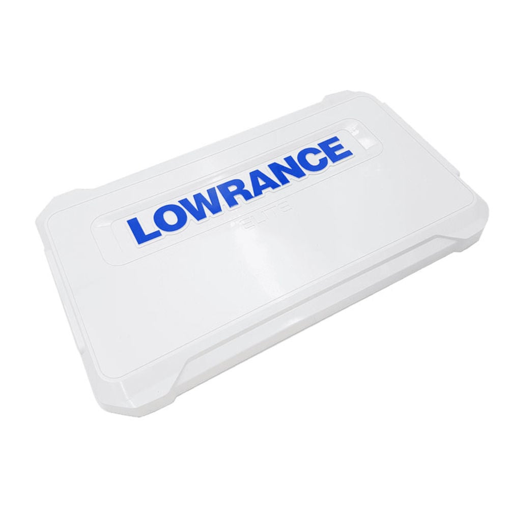
 Elite FS 9 Suncover
Specifications
- Display
- Backlight Color
- Pure White LED
- Display Resolution
- 800x480
- Screen Brightness
- >1200 nits
- Viewing Angles
- 50° top60°bottom70° left/right
- Connectivity
- Bluetooth
- Integrated Bluetooth 4.0 with support for Bluetooth Classic
- Ethernet Ports
- 1 x 100Mbit
- Connectivity Wi Fi
- Internal 802.11b/g/n
- N2K PG Ns
- Receive only65240 ISO Commanded Address, 127245 Rudder, 127251 Rate of Turn, 127257 Attitude, 127488 Engine Parameters, Rapid Update, 127489 Engine Parameters, Dynamic, 127493 Transmission Parameters, Dynamic, 127505 Fluid Level, 127508 Battery Status, 129033 Time and Date, 129038 AIS Class A Position Report, 129039 AIS Class B Position Report, 129040 AIS Class B Extended Position Report, 129794 AIS Class A Static and Voyage Related Data, 129801 AIS Address Safety Related Message, 129802 AIS Safety Related Broadcast Message, 129808 DSC Call Information, 130313 Humidity, 130314 Actual Pressure, 130576 Small Craft Status, 65285 Temperature with Instance, 65325 Reprogramming Status, 65480 Parameter Reply, 130817 Product Information, 130820 Reprogramming Status, 130832 Fuel Used – High Resolution, 130834 Engine and Tank Configuration, 130838 Fluid Level Warning, 130842 AIS and VHF Message Transport, 130843 Sonar Status – Frequency and DSP VoltageTransmit and Receive:59392 ISO Acknowledgement, 59904 ISO Request, 60160 ISO Transport Protocol, Data Transfer, 60416 ISO Transport Protocol, Connection Management, 60928 ISO Address Claim, 126208 NMEA Group Function, 126464 Receive/Transmit PGN’s group function, 126992 System Time, 126996 Product Information, 127237 Heading/Track Control, 127250 Vessel Heading, 127258 Magnetic Variation, 128259 Speed, 128267 Water Depth, 128275 Distance Log, 129025 Position, Rapid Update, 120296 COG and SOG, Rapid Update, 129029 GNSS Position Data, 129283 Cross Track Error, 129284 Navigation Data, 129539 GNSS DOPs, 129540 GNSS Sats In View, 130074 Route and WP Service – WP List - WP Name and Position, 130310 Environmental Parameters, 130311 Environmental Parameters, 130312 Temperature, 130577 Direction Data, 61184 Parameter Command, 65292 Clear Fluid Level Warnings, 65293 LGC-2000 Configuration, 65323 Data User Group Request, 130831 EP-20 Suzuki Engine and EP-50 Storage Device Configuration, 130835 Set Engine and Tank Configuration, 130839 EP-45 Pressure Configuration, 130840 Data User Group Configuration, 130845 Parameter Handle, 130850 Event Command, 130851 Event ReplyTransmit only65287 Temperature Sensor Configuration, 65289 Trim Tab Configuration, 65290 Paddle Wheel Speed Configuration, 130818 Reprogramming Data, 130819 Request Reprogram, 130828 Set Serial Number, 130836 Fluid Level Configuration, 130837 Fuel Flow Turbine Configuration
- NMEA 0183 Sentences supported
- None
- NMEA 2000 Connectivity
- 1x Micro-C
- PC Connectivity
- None
- SD Card Storage
- 1 micro SD card up to 32GB
- Video
- None
- Cartography
- Charts supported
- C-MAP (MAX N, MAX N+)C-MAP GenesisC-MAP Precision Contour HD (AMER ONLY)Navionics (Gold, NAV+ Platinum+)Insight (Pro and HD)Lowrance Regional Mapping Partners
- Electrical
- Power Consumption max
- 2.0A @ 13VDC with backlight on full
- Power Consumption min
- 2.0A @ 13VDC with backlight on full
- Power Consumption typical
- 2.0A @ 13VDC with backlight on full
- Recommended Fuse Rating
- 3A
- Supply Voltage
- 12v DC (10.8-17VDC)
- Environment
- Humidity
- 60°C, 95% relative humidity (RH) for 18 hours
- Operating Temperature Range
- 5°F to 131°F (-15°C to 55°C )
- Shock Vibration
- 100,000 cycles of 20 G
- Storage Temperature Range
- 4°F to 140°F (-20°C to 60°C )
- Waterproofrating
- IPX7 with card door closed
- GPS
- Correction
- DGPSWAASMSASEGNOSGLONASS
- GPS Receiver Channels
- 16
- Position Accuracy
- 20m RMS
- Time to First Fix
- 30s
- Update rate
- 10 Hz
- MFD
- AIS
- AIS Chart overlay. Target vessel details.
- Autopilot
- Outboard PilotGhost Trolling MotorMotorGuide Xi5/Xi3 Trolling Motor **requires Motorguide PinPoint Gateway
- Cartography included
- C-MAP Contour + (US models)Navionics basemap (AMER, AUS/NZ and ROW models)
- Digital Switching
- None
- GPS
- 10 Hz Internal high-sensitivity WAAS + EGNOS + MSAS
- Internal Storage
- None
- Multimedia
- SonicHubSonicHub2FusionLink productsany NMEA 2000 compliant Marine Aduio products
- Sonar Compatibility
- Integrated: CHIRPBroadbandActive Imaging DownScanActive Imaging SideScanCompatible with:SonarHubStructureScanStructurreScan 3DLiveSightActive Target
- Waypoints, Routes, Tracks
- 3000 Waypoints100 Routes100 Trails with up to 10,000 points per trail
- Weather
- SiriusXM via WM-4 (USA only)
- Physical
- Compass Safe
- 12" (300mm)
- Mounting Type
- Gimbal Bracket or Dash Flush Mount
- Weight
- 2.7 lbs (1.2 kg)
- Other
- Interface
- Multi-Touch TouchscreenZoom +/-MOB = (+/- combined)PagesWaypointLight/Power
- Languages
- Standard Language Pack: Afrikaans/Afrikaans, Danish/Dansk, German/Deutsch, English (US), English (UK), Spanish/Español, Finnish/Suomi, French/Français, Greek/Ελληνικά, Icelandic/íslenska, Italian/Italiano, Dutch/Nederlands, Norwegian/Norsk, Portugese (Brazil)/Português (BR), Portugese (Portugal)/Português (PT), Swedish/SvenskaAsian Language Pack: English (US), English (UK), Japanese/日本語, Korean/한국어, Thai/ภาษาไทย, Chinese - (simplified) China/简体中文, Chinese - (traditional) Taiwan/繁體中文Eastern European Language Pack:Bulgarian/Български, German/Deutsch, Estonian/Eesti, English (US), English (UK), Spanish/Español, French/Français, Hebrew/ عبری , Croatian/ Hrvatski, Hungarian/ Magyar, Italian/Italiano, Lithuanian/Lietuvos, Latvian/ Latvijas, Polish/Polski, Slovak/ Slovensky, Turkish/TürkçeRussia/Ukraine Language pack: German/Deutsch, English (US), English (UK), Spanish/Español, Italian/Italiano, Russian/Русский, Ukraine/ УкраїнськаMiddle Eastern Language Pack: Arabic (UAE)/ العربية , German/Deutsch, English (US), English (UK), Farsi/ فارسی , French/Français, Italian/Italiano
- Warranty Period
- 2 Year + 3 additional years of upgrade options totaling 5 years


